For the second half of the summer term you will have an option of doing a project instead of working in the GIS Tutorial 3 book. This project will deal with wind farms, wind energy, and/or wind turbines. Remember the DNR site for great data. Some project ideas are:
-Finding ideal locations for wind farms in Iowa
| Article |
-Creating noise pollution maps
| http://www.wind-energy-the-facts.org/en/part-i-technology/chapter-4-wind-farm-design/factors-affecting-turbine-location/noise.html |
| http://betterplan.squarespace.com/brown-county-ledge-wind-projec/ |
-Show where shadows of turbines fall
| http://www.windturbinesyndrome.com/2010/noise-pollution-from-wind-turbines-minneapolis-star-tribune/ |
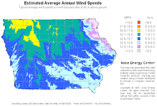
-Show Iowa Wind Patterns
| Link |
| http://www.mapcruzin.com/wind-energy-maps-80-meters/state-wind-maps/free-iowa-wind-energy-maps.htm |
| http://www.iowaenergycenter.org/june-wind-map/ |
-Create a map showing migratory bird patterns and bird or bat species near current wind farms
http://batsandwind.org/pdf/Jain_2005.pdf
http://www.horizonwind.com/images_projects/what_were_doin/TOI_Avian_Annual_Interim_Report_2004_020205.pdf
http://www.iowadnr.gov/portals/idnr/uploads/wildlife/wind_wildliferecs.pdf
-ArcLesson for siting wind farms in Colorado
-Add missing turbines


No comments:
Post a Comment