ArcGIS
Maps (Google)
Google Earth
My Tracks
gvSIG
GPS Essentials
Map Notes
BAO
MyTopo Maps
Soviet Military Maps
MapItFast
GPS Map
GPS Surveyor Free
Anywhere GIS (home page)
Nokia Maps
OruxMaps
MapQuest
Shapefile over Map
Soil Survey Map
Arlington National Cemetery
(business prezi)

Monday, October 29, 2012

Wednesday, September 26, 2012
Louisa County is looking for an IT/GIS Coordinator
Information Technology / GIS Coordinator
Louisa County is accepting applications for a full-time Information Technology / GIS
Coordinator. This position is responsible for maintaining the reliable operation of
the computer networks for the County; selecting and maintaining the County’s
computer hardware and software; providing support and training to end-user
departments to facilitate efficient use of technology; and managing the County’s GIS
system.
To apply, please visit the Louisa County website at www.louisacountyiowa.org.
Deadline for applications is October 12, 2012.
View Larger Map
Louisa County is accepting applications for a full-time Information Technology / GIS
Coordinator. This position is responsible for maintaining the reliable operation of
the computer networks for the County; selecting and maintaining the County’s
computer hardware and software; providing support and training to end-user
departments to facilitate efficient use of technology; and managing the County’s GIS
system.
To apply, please visit the Louisa County website at www.louisacountyiowa.org.
Deadline for applications is October 12, 2012.
View Larger Map
Tuesday, September 25, 2012
Arcgis.com and Google My Maps articles and info
Here is a compilation of various articles, blog entries, and other information related to ArcGIS.com:
All About ArcGIS Online layers
Add Pinterest photos to ArcGIS Online web maps
Embedding ArcGIS Online maps in Facebook
ArcGIS.com Help
Using Google Docs in your ArcGIS Online maps
Adding labels to ArcGIS Online web maps: Part 1
Adding labels to ArcGIS Online web maps: Part 2
Configuring the Public Maps Gallery Template (video)
Using scale visibility ranges for symbology in ArcGIS Online web maps
Add Flickr photos to ArcGIS Online web maps
Tips for displaying photos in pop-ups
Sharing Maps at Specific Locations
Using Custom Basemaps
Using Shapefiles as Basemaps
Here is a compilation of various articles, blog entries, and other information related to Google My Maps:
How To Import Data and Make Maps with Google fusion Tables
How to view ESRI shapefiles in Googlemaps
Google Docs to Google Map
Shapefiles to Google Map
Addresses + Google Docs + Google Maps
All About ArcGIS Online layers
Add Pinterest photos to ArcGIS Online web maps
Embedding ArcGIS Online maps in Facebook
ArcGIS.com Help
Using Google Docs in your ArcGIS Online maps
Adding labels to ArcGIS Online web maps: Part 1
Adding labels to ArcGIS Online web maps: Part 2
Configuring the Public Maps Gallery Template (video)
Using scale visibility ranges for symbology in ArcGIS Online web maps
Add Flickr photos to ArcGIS Online web maps
Tips for displaying photos in pop-ups
Sharing Maps at Specific Locations
Using Custom Basemaps
Using Shapefiles as Basemaps
Here is a compilation of various articles, blog entries, and other information related to Google My Maps:
How To Import Data and Make Maps with Google fusion Tables
How to view ESRI shapefiles in Googlemaps
Google Docs to Google Map
Shapefiles to Google Map
Addresses + Google Docs + Google Maps
Thursday, August 23, 2012
GIS Analyst Position
MINNEHAHA COUNTY invites applications for the position of: GIS Analyst
All applications must be submitted by 5:00 p.m. on the date the position closes.SALARY: $20.40 - $21.97 Hourly
OPENING DATE: 08/22/12
CLOSING DATE: 09/05/12 05:00 PM
GENERAL INFORMATION: The Minnehaha County Planning Department invites applications for GIS Analyst. **Please attach a cover letter and resume to the online application.
EXAMPLES OF DUTIES INCLUDE:
Assist in creating and updating GIS databases including designing spatial and non-spatial GIS data. Monitor parcel base mapping production. Design, document and test applications, programs and systems functionality. Assist in creating and maintaining County's GIS internet applications including application and database design, user interface development, testing and implementation. Maintain GIS data documents, manuals, and system documentation. Digitize, create, update, analyze, and transfer GIS feature datasets. Perform SQL queries, programming scripts, and other functions for geo-database information. Maintain cadastral, planimetric, topographic, planning, and public utility datasets. Analyze aerial photographs and geo-code and capture images and videos. Create surveyed data by reading and researching legal descriptions, aerial information, utility information, and plat sheets. Use ArcGIS including ArcMap, ArcCatalog and ArcSDE to create and edit GIS maps. Perform file transfers to and from the GIS database and perform data transformation, database loading, and extraction activities. Assist in the development of specialized applications and in training interns and end-users. Assist the public by responding to inquiries in person, over the phone, and by email.
MINIMUM QUALIFICATIONS:
Bachelor's degree with emphasis in GIS, geography, engineering, or related field plus one year of experience in database management, graphics, and GIS system software. Equivalent combination of education and experience may be considered. Working knowledge of public records, applied mathematics, and property descriptions. Working knowledge of the principles and practices of land surveying, geographic principles, programming languages, and GIS analysis techniques and computer programming principles. Ability to analyze and resolve problems and to use computer hardware and software systems. Ability to communicate effectively both orally and in writing and establish and maintain effective working relationships with employees, other agencies, and the public. Ability to maintain professional appearance and demeanor.
PREFERRED QUALIFICATIONS:
Experience working with property descriptions. Considerable knowledge of ESRI products, modules, and extensions. Knowledge of ArcGIS, Microsoft Office, GPS, and ArcPad experience.
APPLICATIONS MAY BE FILED ONLINE AT: http://jobs.minnehahacounty.org
OUR OFFICE IS LOCATED AT: 415 N Dakota Avenue Sioux Falls, SD 57104 605-367-4337 jobs@minnehahacounty.org
Job #12-33
GIS ANALYST
JA
Minnehaha County is an Equal Opportunity Employer and does not discriminate on the basis of race, color, creed, religion, national origin, citizenship, ancestry, gender, pregnancy, marital status, sexual orientation, age, disability, veteran's status, genetic information, or any other protected group in accordance with state and federal law. Arrangements for accommodations required by disabilities can be made by contacting Human Resources at (605) 367-4337.
Thursday, July 26, 2012
Warren County, Iowa is seeking a GIS Coordinator
Warren County, Iowa is seeking a GIS Coordinator to oversee
the development, use, maintenance, and support of geospatial technologies
throughout the County. The successful applicant will coordinate all GIS
functions and activities throughout the County, and represent the County at the
regional and State level.
For a full job description and
qualifications please visit www.schneidercorp.com/warren.
All resumes should be sent to jcorns@schneidercorp.com.
Monday, July 16, 2012
Wind Farms and GIS
For the second half of the summer term you will have an option of doing a project instead of working in the GIS Tutorial 3 book. This project will deal with wind farms, wind energy, and/or wind turbines. Remember the DNR site for great data. Some project ideas are:
-Finding ideal locations for wind farms in Iowa
| Article |
-Creating noise pollution maps
 |
 |
| http://www.wind-energy-the-facts.org/en/part-i-technology/chapter-4-wind-farm-design/factors-affecting-turbine-location/noise.html |
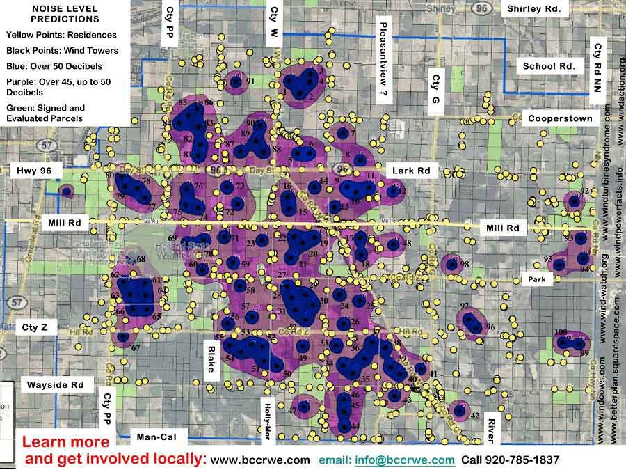 |
| http://betterplan.squarespace.com/brown-county-ledge-wind-projec/ |
-Show where shadows of turbines fall
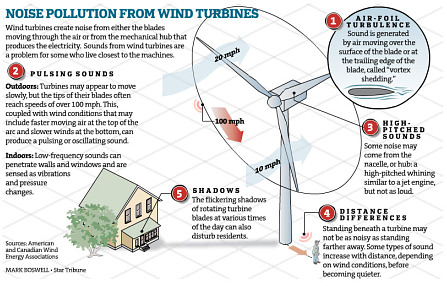 |
| http://www.windturbinesyndrome.com/2010/noise-pollution-from-wind-turbines-minneapolis-star-tribune/ |
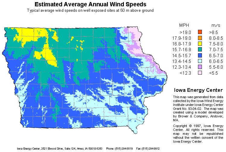
-Show Iowa Wind Patterns
 |
| Link |
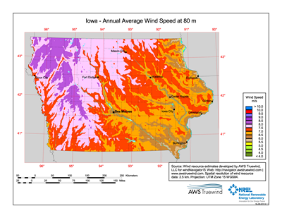 | |||
| http://www.mapcruzin.com/wind-energy-maps-80-meters/state-wind-maps/free-iowa-wind-energy-maps.htm |
 |
| http://www.iowaenergycenter.org/june-wind-map/ |
-Create a map showing migratory bird patterns and bird or bat species near current wind farms
http://batsandwind.org/pdf/Jain_2005.pdf
http://www.horizonwind.com/images_projects/what_were_doin/TOI_Avian_Annual_Interim_Report_2004_020205.pdf
http://www.iowadnr.gov/portals/idnr/uploads/wildlife/wind_wildliferecs.pdf
-ArcLesson for siting wind farms in Colorado
-Add missing turbines
Monday, June 18, 2012
Polk county Auditor's Office job opportunities: http://hr.co.polk.ia.us/employment.htm
Property Description Supervisor
Property Description Specialist
Property Description Supervisor
Under
limited supervision, performs responsible supervisory and technical
work involving property records, GIS base map maintenance, Special
assessments (Drainage & Water Districts), annexations, and Platting
in the Tax Division of the County Auditor's Office.
|
| Illustrative Examples of Work: |
|---|
1. Assists the Tax Manager and GIS Manager with the daily personnel, real estate and taxation functions of the Auditor’s Office.
2. Supervises
and participates in the operations of Real Estate and GIS base map
maintenance including receiving deeds, contracts, and other legal
documents for updating the Real Estate Tax and GIS base map systems.
3. Supervises
and evaluates the work of staff; effectively recommends personnel
actions related to selection, disciplinary procedures, performance,
leaves of absence, grievances, work schedules and assignments and
administers personnel and related policies/ procedures.
4. Reviews, drafts, and provides quality control within the Multiple Versioning GIS base map system
(ARC GIS) including mapped boundaries for parcels, plats,
right-of-ways, easements, taxing authorities, TIF areas, Self Supported
Municipal Improvement Districts, Condominiums, Drainage Districts and
Annexations.
5. Instructs/provides
guidance to employees regarding processes/procedures involved with
various real estate applications (including Transfer Index, Parceling,
Parcel Action, Drainage District and GIS basemap system) and Real Estate
Edit programs (including Homestead Credits, Military Exemptions, and
Family Farm credits).
6. Supervises/approves Drainage District, Benefited Water District assessments; prepares correspondence.
7. Oversees
the reviewing/approving of survey and subdivision plat documents for
recording ensuring compliance with state and local laws;
reviews/approves legal descriptions for the State Development Board
annexations; reviews/drafts TIF boundaries.
8. Supervises/reviews
annexations, Real Estate file updates, and GIS basemap updates; informs
appropriate individuals of annexations or other tax incentives
affecting taxation.
9. Confers
with attorneys, engineers, real estate and business representatives,
developers, departmental and governmental officials, and property owners
on matters concerning real estate title transfers, Drainage Districts,
Annexations, platting, Condominium and other mapped boundaries.
10. Keeps
current on Iowa Code changes that affect real estate, taxation, and GIS
base map maintenance functions; implements required changes in
policy/procedures for compliance with the Iowa Code.
11. Prepares various records and reports.
12. Performs related duties as may be required.
|
| Required Knowledge, Skills and Abilities: |
· Thorough
knowledge of the legal/technical content of property descriptions,
platting/ subdivision of land and real estate taxation.
· Considerable knowledge of modern office practices, procedures and equipment.
· Thorough knowledge of the processing/recording of documents affecting property ownership and taxation.
· Considerable knowledge of state and local laws/regulations pertaining to real estate /taxation.
· Considerable knowledge of GIS, ARC GIS in a multi-versioned environment and Microsoft Office Suite.
· Knowledge of trigonometry, analytical geometry, and calculus.
· Working knowledge of land surveying practices.
· Ability to work with a minimum of supervision in group situations and under pressure.
· Ability to write and interpret difficult legal descriptions.
· Ability to read/interpret property description records and reach appropriate conclusions.
· Skill in the complex application of property terms, procedures and techniques.
· Ability to answer difficult inquiries regarding tax laws or procedures.
· Ability to communicate effectively both verbally and in writing.
· Ability to effectively supervise and evaluate the work of staff.
· Ability
to establish and maintain effective working relationships with
co-workers, the general public, real estate agents, engineers, attorneys
and other professionals.
|
| Training and Experience: |
· Bachelor’s Degree in Geography, GIS, Cartography, Civil Engineering or related field and
· Three
years of experience in property description, real estate/subdivision
work, GIS cadastral base map maintenance (ARC GIS) or related, or
· Any equivalent combination of training and experience that will have provided the required knowledge, skills and abilities.
|
Property Description Specialist
Under
general supervision, performs complex and specialized property records
and tax assessment work; and directs the receipt of deeds and contracts
in predetermined areas.
|
| Illustrative Examples of Work: |
|---|
1. Ascertains
the legal and technical content of property descriptions in
interpreting deeds, contracts, surveys and condemnations; coordinates
and participates in the receipt of deeds and contracts and completion of
specialized property records work in the County Auditor's Office,
requiring the ability to write and interpret difficult legal
descriptions.
2. Approves,
locates, describes and puts data into final form for computer entries;
maintains the GIS cadastral base map using trigonometry, coordinate
geometry, and following the GIS cadastral mapping standards.
3. Directs and makes title changes when necessary based on legal and technical content for tax purposes.
4. Assists in directing and reviewing the work of other divisional staff in predetermined areas.
5. Calculates and certifies to the Treasurer, assessments for drainage and water districts as required.
6. Conducts title searches; maintains a general knowledge of transfer books, index and microfilm procedures.
7. Provides
various information to the general public, governmental bodies,
engineers, attorneys, title companies and other professionals.
8. Maintains applicable records and reports.
9. Performs related duties as may be required.
|
| Required Knowledge, Skills and Abilities: |
· Thorough knowledge of the terms, procedures and techniques used in property description and record keeping.
· Considerable knowledge of modern office practices, techniques and equipment.
· Knowledge of the codes and ordinances that govern the description and division of land.
· Knowledge of mechanical drawing practices associated with property records work.
· Knowledge of Geographic Information System concepts/methodology.
· Knowledge of methods, techniques, and instruments used in cadastral mapping.
· Knowledge of trigonometry, analytical geometry, and calculus.
· Ability to edit cadastral maps in an ArcGIS software environment.
· Ability to write and interpret difficult legal descriptions.
· Ability to read and interpret property description records and reach appropriate conclusions.
· Ability to perform work requiring exceptional attention to accuracy and speed.
· Ability to follow verbal and written instructions.
· Ability to maintain technical property records.
· Ability to execute difficult drawings and change the GIS basemap.
· Skill in the complex application of property terms, procedures and techniques.
· Skill in cadastral mapping.
· Ability
to establish/maintain effective working relationships with co-workers,
the general public, real estate agents, engineers, attorneys and other
professionals. .
|
| Training and Experience: |
· Graduation from high school, and
· Associate’s Degree in Geography, GIS, Cartography, Civil Engineering or related field and
· Successful completion of high school or college trigonometry, and
· Three years of cadastral map editing or related experience, or
· Any equivalent combination of training and experience that will have provided the required knowledge, skills, and abilities.
|
Subscribe to:
Posts (Atom)